Piton Maïdo
Piton Maïdo
At 2,205 meters altitude in the Hauts de Saint-Paul, Piton Maïdo offers a breathtaking plunge into the Cirque de Mafate, accessible only on foot. An exceptional panorama of the cliffs and islets of this UNESCO-listed territory.
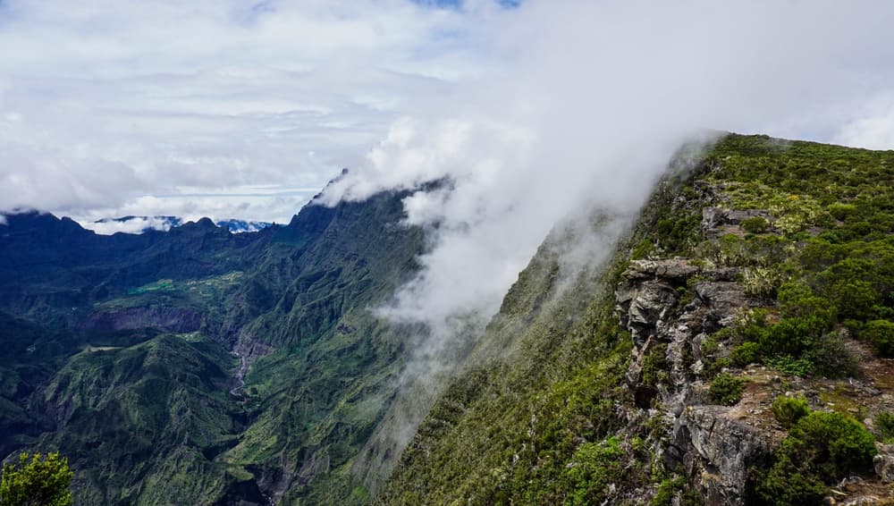
Piton Maïdo rises to 2,205 meters altitude in the highlands of Saint-Paul on Réunion. From the viewing platform at the summit, your gaze plunges directly into the Cirque de Mafate, one of the island's three volcanic cirques, accessible only on foot or by helicopter. This vertiginous panorama over the cliff walls, inhabited islets, and forested ridges makes it one of the most striking viewpoints on the island.
Quick facts
- Access: forest road from La Possession or Saint-Paul via the village of Sans-Souci—road occasionally closed at night or in poor weather.
- Parking: large free parking lot at the viewpoint.
- Recommended time: 30 minutes to 1 hour for the viewpoint alone; half-day to full day if hiking.
- What to wear: warm clothing recommended—wind and cold can be intense even in the southern summer.
- Weather: arrive early in the morning; clouds frequently shroud the summit by late morning.
- Accessibility: the main viewpoint is accessible; the hiking trail is not.
What to see
From the viewpoint, the vista embraces the entire Cirque de Mafate: the vertical cliff walls, the islets of Roche-Plate, La Nouvelle, Marla and Aurère, and on clear days, the west coast of the island stretching to the Indian Ocean. Below, the forest of Acacia heterophylla covers the slopes. In exceptional conditions, Piton des Neiges and Piton de la Fournaise stand out on the horizon.
History and context
The name "Maïdo" comes from Malagasy and means "burned forest," recalling the fires that once ravaged these highlands. The site belongs to the Réunion National Park, designated a UNESCO World Heritage site in 2010 under the Pitons, Cirques and Escarpments designation. The forest road leading there has been progressively developed to allow public access while preserving high-altitude ecosystems.
Highlights of the visit
Sunrise over Mafate
Arriving before dawn is the most sought-after experience. The first raking light colors the cliff walls in ochre and rose, while a sea of clouds sometimes fills the cirque floor below. The air is crisp; bring an extra layer.
The GR R2 trail and ridge paths
Several marked trails depart from the parking area. The GR R2 crosses the ridges toward Piton des Neiges. Shorter loops run along the Acacia heterophylla forest, habitat of endemic species like the tuit-tuit (a protected bird).
The Acacia forest
On the way to the summit, the road passes through a dense forest of Acacia heterophylla (Acacia heterophylla), an endemic species of Réunion. This forest shelters protected fauna and flora characteristic of the island's highlands.
Photography tips
Light is optimal between 6 a.m. and 9 a.m.: shadows cast on the cliff walls are pronounced and the sky usually remains clear. A wide-angle lens captures the scale of the cirque; a telephoto lens isolates the islets below. Avoid midday, when clouds regularly obscure the view. No photographic restrictions on the public viewpoint.
Location and access
Piton Maïdo sits in the Hauts de Saint-Paul on the west coast of Réunion. The access road leaves Sans-Souci (Saint-Paul municipality) and climbs about 30 kilometers of winding forest road. No regular public transport serves the summit; a personal vehicle or organized excursion is necessary. Local agencies offer transfers and guided hikes from Saint-Gilles-les-Bains or Saint-Denis.
Nearby attractions
- Cirque de Mafate — the cirque you overlook from the viewpoint, accessible only on foot or by helicopter.
- Saint-Gilles-les-Bains — a beach resort on the west coast, a convenient starting point to reach Maïdo.
- Piton des Neiges — the island's highest peak (3,070 m), linked to Maïdo by the GR R2.
- Bélouve Forest — another emblematic high-altitude forest on Réunion, on the eastern side.
Nearby
Interested in this visit?
We can include it in your personalised itinerary.