Hiking from Cilaos to Piton des Neiges
Hiking from Cilaos to Piton des Neiges
From Cilaos, the GR R2 trail leads to Piton des Neiges (3,070 m), the highest point in the Indian Ocean. Two days of hiking, one night at altitude, and a sunrise over the three cirques of La Réunion.
Piton des Neiges rises to 3,070 metres, the highest point in the Indian Ocean. From the Cilaos cirque, the classic trail reaches it in two days via the Caverne Dufour shelter. An extinct volcano with flanks sculpted by erosion, it offers panoramic views of the three cirques of La Réunion and, on clear days, all the way to the island's coastlines. This is the signature hike for anyone visiting La Réunion.
Quick practical info
- Starting point: Cilaos, marked trail in white and red (GR R2)
- Recommended duration: 2 days / 1 night at Caverne Dufour shelter (reservation mandatory)
- Difficulty: Challenging — approximately 1,600 m elevation gain from Cilaos
- Access: Cilaos is accessible from Saint-Louis by national road (winding road, approximately 1 hour 30 minutes from Saint-Denis)
- What to wear: High-ankle hiking boots essential; warm clothing for the night at altitude (temperatures near 0 °C at the summit)
- Shelter booking: Mandatory, limited capacity — plan several weeks ahead during peak season
- Accessibility: Not wheelchair accessible
What you'll see
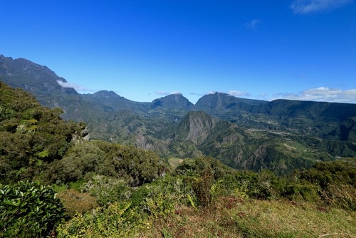
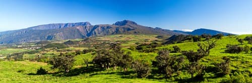
The trail first crosses the cultivated slopes of Cilaos — lentils, vineyards — before descending into a forest of highland tamarinds. Higher up, vegetation becomes sparse, giving way to heath and volcanic rock. At the summit, the collapsed crater reveals an ancient caldera. On clear days, the cirques of Mafate, Salazie, and Cilaos appear simultaneously.
History and context
Piton des Neiges is a shield stratovolcano that has been extinct for approximately 12,000 years. It forms the geological core of La Réunion, far older than the still-active Piton de la Fournaise. Its name evokes the nocturnal frosts that sometimes whiten the summit during the austral winter. The massif is listed as a UNESCO World Heritage site as part of the "Pitons, cirques and ramparts of the island of La Réunion".
Highlights of the experience
Sunrise at the summit
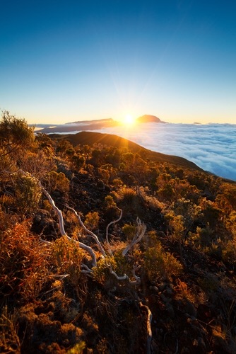
Most hikers leave the Caverne Dufour shelter around 3 a.m. to reach the summit before dawn. The spectacle — a sea of clouds tinted orange, the silhouette of Piton de la Fournaise on the horizon — justifies the nocturnal effort. A headlamp is essential.
The highland tamarind forest
Between 1,800 and 2,400 metres, the trail crosses an endemic forest of tamarinds (Acacia heterophylla), a species unique to La Réunion. The twisted trunks and filtered light create a distinctive atmosphere, especially early in the morning.
Caverne Dufour shelter
Located at approximately 2,479 metres, this shelter managed by the National Park is the only accommodation on the route. Hot meals served in the evening. A night at altitude, with the starlit sky above the clouds, is an experience in itself.
The view over the three cirques
From the summit, the cirques of Cilaos, Mafate, and Salazie unfold below. Each cirque displays distinct morphology: Cilaos more open and cultivated, Mafate accessible only on foot or by helicopter, Salazie greener and more lush.
Photography tips
Light is optimal in the 30 minutes following sunrise at the summit. After 8 a.m., clouds typically invade the cirques and obscure the panoramas. A wide-angle lens showcases the sweep of the landscape. The night at the shelter offers interesting conditions for astrophotography — virtually no light pollution at this altitude.
Location and access
The starting point is the town of Cilaos, in the cirque of the same name, in central La Réunion. The GR R2 trail is marked in white and red from the town centre. Cilaos is not served by the regional bus network in a way that's practical for an early-morning hike; a personal vehicle or taxi from Saint-Louis is recommended. Local agencies offer organised packages with transfers and shelter bookings included.
Nearby attractions
- Cirque of Cilaos — The thermal village and its renowned lentils, an ideal starting point for exploring the cirque before or after the hike.
- Cirque of Mafate — Accessible only on foot or by helicopter, visible from the summit of Piton des Neiges.
- Cirque of Salazie — The island's third cirque, wetter, known for its waterfalls and the village of Hell-Bourg.
- Piton de la Fournaise — Active volcano in the south-east of the island, the other major volcanic hike in La Réunion.
Frequently asked questions
The austral dry season (May to November) offers the best conditions: less rain, clearer visibility at the summit. The austral summer (December to April) coincides with the cyclone season — risks of intense rain and persistent fog.
Yes. The shelter has limited capacity and demand is high during peak season (July-August, school holidays). Reserve several weeks, even several months ahead. The shelter is managed by La Réunion National Park.
Technically possible for very fit hikers, but not recommended. The elevation gain and distance make it exhausting, and you'll miss the sunrise at the summit, the signature moment of this hike.
High-ankle hiking boots, warm and waterproof clothing (the summit can approach 0 °C at night), headlamp with spare batteries, adequate water, energy snacks. The shelter provides meals and sleeping bags.
The GR R2 is marked in white and red throughout the route. At night, between the shelter and the summit, pay attention to marks on the rocks. A GPS or offline IGN map is a useful complement.
Yes, the GR R2 crosses through Mafate. Multi-day itineraries allow you to link Cilaos, Piton des Neiges, and Mafate. This requires good fitness and more complex logistics (multiple shelters to book).
Photos
Give it a go!
Our local experts arrange this activity for you.