Dos d'Âne to Cap Noir Hike
Dos d'Âne to Cap Noir Hike
From the village of Dos d'Âne, this trail leads to Cap Noir, a basalt promontory offering a dramatic descent into Mafate Cirque and the Rivière des Galets gorges. A half-day hike accessible without technical equipment.
Starting from the village of Dos d'Âne in the Hauts of La Possession, this trail leads to Cap Noir, a volcanic rock spur suspended above the Rivière des Galets gorges. The panorama over Mafate Cirque and the surrounding ramparts is among the most breathtaking on the island, accessible without technical gear. It's a half-day hike, beloved by locals and visitors alike.
Quick reference
- Access: departing from Dos d'Âne village (La Possession), reachable by car via the RN1 and then the Hauts road.
- Admission: free, public trail.
- Recommended duration: 2 h 30 to 3 h 30 round trip depending on pace.
- Difficulty: moderate — some narrow cliff-edge sections.
- What to bring: hiking boots mandatory, hat and water essential.
- Accessibility: not suitable for people with reduced mobility.
What to see
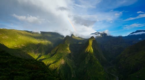
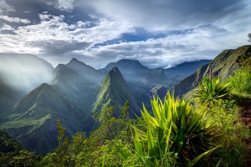
The trail first winds through tamarisk and highland vegetation before opening onto the ramparts. At Cap Noir, the view plunges down into the narrow Rivière des Galets gorges and sweeps across Mafate Cirque: perched settlements, jagged ridges, basalt walls. On clear days, the gaze extends to the island's western coast.
History and context
Dos d'Âne is a highland village founded by colonists and freedmen seeking arable land away from the coast. Cap Noir owes its name to the dark colour of the volcanic rock that forms it. This type of basalt promontory is characteristic of the ramparts encircling Réunion's cirques, shaped by differential erosion over millions of years.
Highlights of the visit
The Cap Noir overlook
Arriving at Cap Noir marks the climax of the hike. The spur offers a 180° view of Mafate without requiring descent into the cirque. It's one of the few viewpoints over Mafate accessible without crossing the ramparts.
The Rivière des Galets gorges
Below, the Rivière des Galets has carved one of Réunion's deepest valleys. The contrast between green vegetation on the slopes and the rocky riverbed is particularly striking in the dry season.
Highland vegetation
Along the path, mountain tamarisks, tree ferns and native flowers border the trail. This endemic flora is representative of the island's semi-arid mountain forests.
Photography tips
Morning light is ideal: cirques are often shrouded in clouds by late morning, especially in the humid season. Position yourself at the tip of Cap Noir to frame Mafate's ramparts without obstruction. A wide-angle lens does justice to the gorges' scale.
Location and access
The starting point is at Dos d'Âne village in the Hauts of La Possession, on the west side of Réunion. Reach it from Saint-Paul or Saint-Denis via the RN1, then head up toward the Hauts. Parking is at village level. No regular shuttle serves this trailhead; a personal vehicle is necessary.
Nearby attractions
- Mafate Cirque — the cirque you overlook from Cap Noir; accessible on foot via the ramparts for a full immersion.
- Dos d'Âne Village — the hike's starting point, with a few picnic tables and a preserved highland village atmosphere.
- Rivière des Galets — the island's largest river by flow, visible from Cap Noir's heights.
Frequently asked questions
The dry season (May to November) offers the best conditions: clear skies, less slippery trails, sharper views of Mafate. In the humid season, clouds envelop the cirques from mid-morning onward.
Difficulty is moderate. A few sections run along unprotected cliffs; children should be supervised. Hiking boots with grip soles are essential, especially in humid conditions.
Cap Noir is an overlook, not a direct gateway to the cirque. To enter Mafate, other marked trails from Dos d'Âne or Roche Plate allow descent, but require a full day and good fitness.
No refreshment points on the trail. Bring enough water (at least 1.5 litres per person) and snacks. Dos d'Âne village has a few amenities at the start.
Yes, without restriction. The site is outdoors on public land. Avoid standing too close to cliff edges when framing shots.
Interested in this visit?
We can include it in your personalised itinerary.