Maïdo to Grand Bénare Hike
Maïdo to Grand Bénare Hike
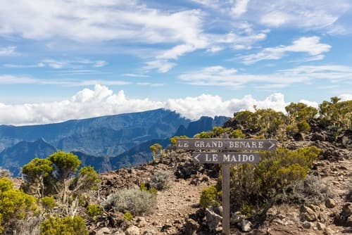
From the Maïdo viewpoint, the hike to Grand Bénare (2,898 m) crosses high-altitude moorlands and volcanic ridges to offer a sweeping view over the Mafate cirque. A demanding day's outing, reserved for experienced hikers.
Grand Bénare peaks at 2,898 metres, the highest point of the Hauts de Saint-Paul. The hike from Maïdo connects two of Réunion's most spectacular viewpoints: the Mafate cirque rampart on one side, volcanic ridges on the other. This is a demanding outing, reserved for experienced hikers, offering complete immersion in high-altitude vegetation and Réunion's moorland landscapes.
Quick reference information
- Start access: Maïdo viewpoint car park, accessible from Saint-Paul via the Maïdo forest road (RD 24)
- Difficulty level: challenging — significant elevation gain, terrain sometimes exposed and windy
- Recommended duration: full day (allow 6 to 8 hours return depending on pace)
- Clothing: sturdy hiking boots mandatory, warm clothing and windproof layer (cool temperatures at summit even in summer)
- Water: no water sources on the route — bring sufficient supplies
- Best season: dry season (May to November) recommended; avoid foggy or rainy conditions (slippery trail, zero visibility)
- Wheelchair access: not accessible
What you'll see
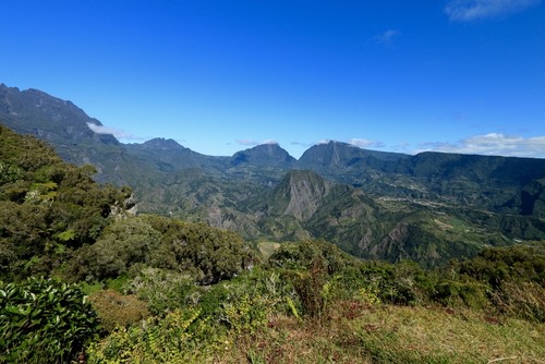
The trail first crosses the tamarind forest of the Hauts before opening onto the high-altitude moorland, dotted with branles and Psiadia flowers. As you gain altitude, vegetation becomes sparser and gives way to wind-swept rocky ridges. At the summit of Grand Bénare, the panorama encompasses the Mafate cirque in all its depth, the sheer ramparts and, on clear days, a large portion of the island.
History and context
Maïdo is an emblematic site in the Hauts of western Réunion, long frequented by hunters and herders before becoming a major hiking destination. Grand Bénare, the highest point of the Maïdo massif, belongs to Réunion National Park, listed as a UNESCO World Heritage site in 2010 for its rich endemic biodiversity.
Highlights of the visit
The Maïdo viewpoint
Even before beginning the climb to Grand Bénare, the Maïdo viewpoint offers a vertiginous plunge over the Mafate cirque and its isolated islets. Clouds often form here by late morning — leave early to make the most of clear skies.
The high-altitude moorland
Between 2,200 and 2,800 metres, the landscape changes dramatically. The branle moorland, volcanic rocks and near-total silence create a unique atmosphere, very different from the rest of the island. A few endemic bird species, such as the tuit-tuit or Réunion merle, can be spotted in this zone.
The summit of Grand Bénare
At 2,898 metres, the panorama is circular on clear days: Mafate below, surrounding peaks and ramparts, and sometimes Piton des Neiges in the distance. Wind can be fierce — plan extra layers for your summit break.
Photography tips
Light is optimal in early morning, before orographic clouds arrive on the ridges around 10am-11am. From the summit, frame towards Mafate for sweeping views over the islets. Flowering branle moorland (July-August) offers colourful foregrounds. Avoid using flash with endemic wildlife.
Location and access
The hike begins from the Maïdo viewpoint, located in the Hauts de Saint-Paul, about 30 km from the city centre via the forest road. The road is winding and narrow in places. No public transport serves Maïdo — a personal vehicle or car rental is essential. Parking is free. Guided tours of the Mafate cirque can be combined with this hike for a more complete immersion.
Nearby attractions
- Maïdo viewpoint — start of the hike, sweeping view over Mafate accessible to all.
- Mafate cirque — enclosed cirque visible from the ridges, accessible only on foot or by helicopter.
- Piton des Neiges — island's highest peak (3,070 m), another major high-altitude hike on Réunion.
- Saint-Paul — coastal town below, with its market and waterfront, to recover after the effort.
Frequently asked questions
The dry season, from May to November, is most favourable. Risks of rain and fog are lower, and trails remain passable. During the rainy season (December to April), terrain becomes slippery and summit visibility is often zero.
Yes. The elevation gain is significant and some ridge sections are exposed to wind. Good physical fitness and mountain hiking experience are necessary. This isn't suitable for beginners or young children.
Yes, routes allow you to descend into the Mafate cirque from the ridges. This requires planning accommodation in an islet (guesthouses available) and organising the outing in advance, as Mafate is only accessible by trail.
Even in southern summer, temperatures at Grand Bénare can drop below 10°C with wind. Pack a windproof layer, warm clothing, sturdy hiking boots and a hat. Sun protection is essential at altitude.
No guide is mandatory, but using a local mountain guide is strongly recommended for a first visit, especially for managing changing weather and navigation on the ridges.
Departure before 7am is recommended to reach the summit before clouds arrive and return before nightfall. Days are short in southern winter (June-August).
Give it a go!
Our local experts arrange this activity for you.