Hiking Piton de la Fournaise – Pas de Bellecombe and Dolomieu Crater
Hiking Piton de la Fournaise – Pas de Bellecombe and Dolomieu Crater
From Pas de Bellecombe, cross the Enclos Fouqué to reach the Dolomieu crater of Piton de la Fournaise, one of the world's most active volcanoes. An extraordinary volcanic hike in the heart of Réunion.
Piton de la Fournaise is one of the world's most active volcanoes. From the Pas de Bellecombe-Jacob parking area, at approximately 2,300 m elevation, a hiking trail crosses the Enclos Fouqué to reach the Dolomieu crater. The lunar landscape of solidified lava, fumaroles, and the silhouette of the terminal cone make this one of the most striking volcanic experiences on the island of Réunion.
Quick facts
- Access: Route du Volcan (RN3) from Le Tampon or Sainte-Rose; Pas de Bellecombe-Jacob parking at the end of the road.
- Entrance: Free (excluding possible guide fees).
- Recommended duration: 4 to 6 hours round trip depending on pace and destination (crater edge or summit).
- Difficulty: Moderate to difficult — irregular volcanic terrain, positive elevation gain of approximately 500 m from the parking area.
- Closures: The trail closes without notice in the event of eruption or volcanic alert; check conditions with the OVPF (Observatoire Volcanologique du Piton de la Fournaise) before departure.
- Gear: Hiking boots mandatory, windbreaker, sufficient water, sun protection.
- Accessibility: Not accessible — raw volcanic terrain.
What to see
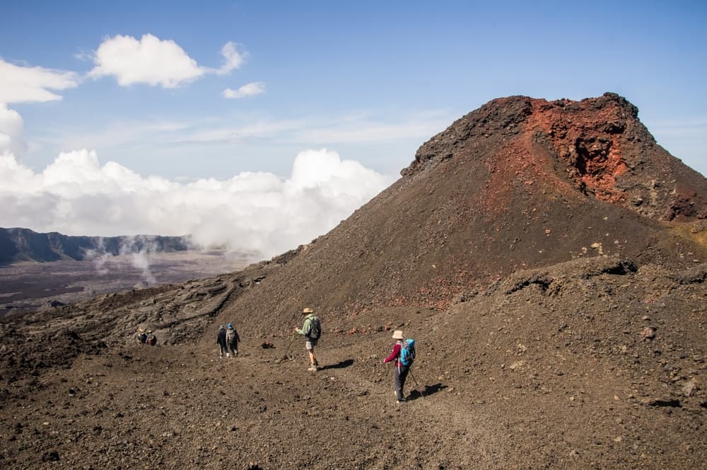
The trail begins with a staircase carved into the Pas de Bellecombe cliff, then descends into the Enclos Fouqué, a vast caldera several kilometers in diameter. The ground alternates between pahoehoe lava flows (smooth and ropy) and aa lava (chaotic and jagged). The Dolomieu cone rises in the center; its summit crater measures approximately 1 km in diameter and several hundred meters in depth.
History and context
Piton de la Fournaise has been active for hundreds of thousands of years. It erupts several times per year on average, making it one of the most closely monitored volcanoes in the world. The Enclos Fouqué formed during a caldera collapse approximately 5,000 years ago. The Dolomieu crater itself experienced a major collapse during the 2007 eruption, radically altering its morphology.
Highlights of the visit
The descent into the Enclos Fouqué
The Pas de Bellecombe staircase offers a plunging view over the caldera before even stepping onto the lava. The transition from cliff vegetation to the mineral desert of the Enclos is immediate and spectacular.
Crossing the lava flows
Yellow blazes and cairns guide you across terrain that changes texture with every step. Recent flows, black and glossy, contrast with older zones, reddish and oxidized. Some fumaroles remain visible near the fissures.
The rim of Dolomieu crater
Reaching the edge of the Dolomieu reveals a vertiginous chasm with walls striped in red, ochre, and black. On clear days, views extend to the sea. In post-eruptive periods, plumes of sulfurous gas escape from below.
Photography tips
Morning light, before clouds rise from the coasts, is ideal. From Pas de Bellecombe, the backlighting of the sunrise over the cone is particularly striking. At the crater rim, frame wide to convey the scale. Avoid flash: it is useless over such vast expanses. Protect your camera from fine volcanic dust.
Location and access
Pas de Bellecombe-Jacob parking sits at the end of Route du Volcan, accessible from Le Tampon (west slope) or from Sainte-Rose (east slope). No regular public transport serves this location; a personal vehicle or organized shuttle is necessary. Local agencies offer transfers and guided hikes from Saint-Denis, Saint-Pierre, or Saint-Benoît.
Nearby attractions
- Plaine des Sables — volcanic ash desert crossed en route to the volcano, a Martian landscape not to be missed before reaching the parking area.
- Gîte du Volcan — high-altitude lodging allowing you to set out at dawn to avoid morning clouds.
- Sainte-Rose — coastal village where historic lava flows crossed the Notre-Dame-des-Laves church, a living testament to volcanic activity.
- Notre-Dame-des-Laves — church spared by the 1977 lava flow, a powerful symbol of the bond between Réunion residents and their volcano.
Frequently asked questions
Check the OVPF website (Observatoire Volcanologique du Piton de la Fournaise) or the Préfecture de Réunion website. In the event of eruption or alert, access to the Enclos is forbidden and barriers are closed on the road.
The austral dry season (May to November) offers the best chances of clear skies. During austral summer (December to April), clouds quickly overtake the massif by mid-morning. Always start early, ideally at dawn.
The marked trail is passable without a guide for experienced hikers. A certified guide is recommended for beginners, in poor visibility, or to understand volcanic geology in detail.
During an active eruption, access to the Enclos is closed for safety reasons. Observation points are sometimes set up along the road by authorities. Inquire with the Préfecture.
Plan for a minimum of 2 liters per person. There are no water sources on the trail. Sun and wind at altitude dehydrate quickly, even on overcast days.
Yes. Descending via the east slope, Sainte-Rose is accessible in less than an hour by car from the parking area. The Notre-Dame-des-Laves church and waterfront round out a volcanic day nicely.
Give it a go!
Our local experts arrange this activity for you.