Piton de la Fournaise
An active volcano reaching 2,632 meters, Piton de la Fournaise is climbed in 5 to 6 hours from Pas de Bellecombe, after crossing the mineral landscape of Plaine des Sables.
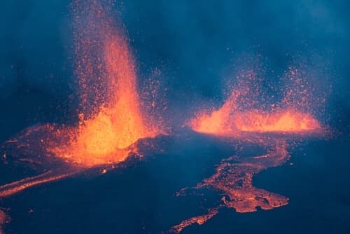
Piton de la Fournaise dominates the entire southeast of the island, from Plaine des Cafres at 1,600 meters to its summit at 2,632 meters. It is one of the world's most active volcanoes: an eruption roughly every nine months on average, with over 80 recorded episodes since 1900. Our agency monitors the bulletin from the Piton de la Fournaise Volcanological Observatory in Bourg-Murat, which publishes real-time seismic activity and allows us to redirect an itinerary within 24 hours should a new lava flow open.
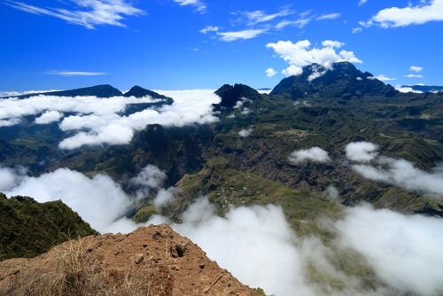
The route from Saint-Pierre or Saint-Denis follows the Volcano forest road, a regional highway climbing 30 kilometers through high-altitude pastures of Plaine des Cafres. You'll pass dairy herds that supply the local cheese industry, notably Bourg-Murat cheese. At Nez de Bœuf pass, the view plunges over Rivière des Remparts, a valley 1,000 meters deep carved through ancient lava flows. Higher up, the landscape transforms: vegetation vanishes, replaced by red and black scoria of Plaine des Sables. This plateau, 9 kilometers long at 2,200 meters altitude, is the ancient floor of a caldera, crossed by a track that takes standard vehicles 25 minutes to traverse.
Access to the crater is from the Pas de Bellecombe parking area, the road's terminus. From there, a metal stairway descends 200 meters into Enclos Fouqué, the volcano's active caldera. The trail then crosses a lava field where smooth pahoehoe flows alternate with jagged aa flows, until reaching the foot of Dolomieu cinder cone, which collapsed 300 meters deep in 2007. The round-trip hike takes 5 to 6 hours, with no shade or water sources. We organize departures before 6 a.m.: the sea of clouds rises from the coast and reaches the crater rim around 10 a.m., obscuring everything for the rest of the day.
Below, the village of Bourg-Murat on Plaine des Cafres concentrates high-altitude accommodations and Cité du Volcan, a scenographic museum renovated in 2014 that traces 500,000 years of the island's volcanic history. A two-hour visit before the hike illuminates the terrain: difference between Bory and Fouqué enclosures, formation of lava tunnels in Plaine des Sables, mechanics of flank eruptions. The museum restaurant serves a smoked curry that sustains you well before a day at altitude.
When an eruption is underway, the trail to Dolomieu closes and the prefecture opens access to Piton de Bert viewpoint or the Tremblet road depending on fissure location. In 2007, the Tremblet flow reached the ocean in 36 hours and created a black sand beach still visible today. These episodes attract Réunionnais who climb to keep vigil at night: it is a moment when Creole culture resonates directly with the volcano, designated in maloya songs as a living presence of the island.
The volcano region sets itself apart from the rest of the island through its dry, cool climate, mineral landscapes, and absence of swimming. It logically connects with the Sauvage South downstream, where recent flows cut the coastal road between Sainte-Rose and Saint-Philippe, and offers useful contrast with the humid cirques of Salazie or Mafate. It's a short but structuring stage in an island circuit, provided you time the weather well.
To discover
Crossing Plaine des Sables. Nine kilometers of red and black scoria at 2,200 meters, ancient caldera floor that you traverse by high-clearance vehicle or 4x4 between Pas des Sables and Pas de Bellecombe.
Hike to Dolomieu crater. Five to six hours round-trip from Pas de Bellecombe, with a 200-meter descent into Enclos Fouqué and crossing lava fields to the cinder cone that collapsed in 2007.
Cité du Volcan in Bourg-Murat. Scenographic museum renovated in 2014, two hours to understand eruption mechanics before heading up to the crater.
Tremblet flows to the ocean. Along the southeast coastal road, crossing the 2007 lava field that cut the RN2 and created a black sand beach at the mouth.
Piton de Bert viewpoint during eruption. Viewpoint opened by the prefecture when a fissure activates on the south flank, accessible on foot from Pas de Bellecombe depending on restricted zones.
When to go
The most reliable months for climbing the volcano run from May to November, the austral dry season. Temperatures at 2,200 meters range between 4 and 8 degrees at sunrise, and 15 to 18 degrees mid-morning, with often clear skies until 10 a.m. From December to April, the rainy season accumulates 300 to 500 mm monthly on the heights and clouds settle in by 8 a.m.: we advise against hiking to Dolomieu during this period, except for a confirmed window the day before.
The contrast with the coast is stark. When Saint-Pierre shows 28 degrees in July, Bourg-Murat drops to 6 degrees at night and sometimes freezes at Pas de Bellecombe in August. A fleece, windbreaker, and hat are necessary year-round for early morning departure, even during peak austral summer.
Practical advice
We recommend two nights on-site, one in Bourg-Murat or Plaine des Cafres before the hike, one after to recover or continue toward Piton de Textor and Bébour forest. Plan a full day for Dolomieu, departure 5:30 a.m., return around 2 p.m. Access is via the Volcano forest road from Saint-Pierre (1.5 hours) or Saint-Benoît via Plaine des Palmistes (2 hours). No public transport serves Pas de Bellecombe; a rental car is essential.
The region links well with Sauvage South by descending toward Saint-Philippe and recent flows, or with Cirque de Cilaos via the Plaine des Cafres road. Comfort is limited to simple, well-kept high-altitude guesthouses and bed-and-breakfasts. It's a stage suited to trained hikers for Dolomieu, but also to those content with the Pas de Bellecombe viewpoint without descending into the enclosure. With children, we adapt the outing to Rosemont Chapel trail, two hours on flat terrain in Plaine des Sables.