Aurère – Deux Bras Hiking Trail (Salazie Cirque)
Aurère – Deux Bras Hiking Trail (Salazie Cirque)
Between basalt cliffs and humid forests, the Aurère – Deux Bras hiking trail crosses two isolated Creole hamlets in Salazie Cirque. A challenging trail, away from the crowds, to discover authentic Réunion.
At the heart of Salazie Cirque, the Aurère – Deux Bras hiking trail connects two inhabited hamlets perched in a landscape of basalt cliffs, deep ravines and humid forests. This little-frequented path offers immersion in the isolated Creole life of Réunion, far from conventional tourist circuits. The crossing demands good physical fitness but rewards with striking views of the cirque's ramparts and lush vegetation.
Quick practical info
- Access: Starting from Îlet Aurère, accessible via the Salazie road then a track from Hell-Bourg or Mare à Vieille Place.
- Recommended duration: Allow a full day (6 to 8 hours of walking depending on pace).
- Difficulty level: Challenging — significant elevation gain, steep sections, terrain sometimes slippery in humid conditions.
- Entrance fee: Free.
- What to wear: Waterproof hiking boots essential; warm clothing and windproof jacket recommended (the cirque is often shrouded in clouds).
- Accessibility: Not accessible for people with reduced mobility.
What you'll see
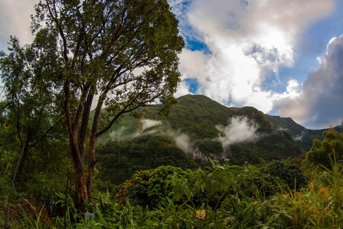
The trail crosses forests of highland tamarinds and tree ferns, follows deeply cut ravines and navigates several passages along the cliff face. Îlet Deux Bras, a tiny Creole hamlet, retains traditional wooden and corrugated iron architecture. Panoramic views of Salazie Cirque's ramparts and surrounding waterfalls punctuate the journey regularly.
History and context
Aurère and Deux Bras are among Réunion's most isolated hamlets. Populated since the 19th century by Creole families, these villages long lived in near self-sufficiency, cultivating vanilla, geranium and food crops. The absence of a passable road until recent times preserved their authentic character. The trail connecting them is one of the few physical links between these communities and the rest of the cirque.
Highlights of the visit
Salazie Cirque's ramparts
Throughout the hike, the cirque's vertical cliffs dominate the landscape. Ancient lava flows, sculpted by erosion, form walls in ochre and black tones that vegetation progressively colonizes.
Îlet Deux Bras
Reaching Deux Bras after several hours of hiking gives a true sense of the isolation of its inhabitants. Traditional Creole houses, terraced gardens and the welcome from residents make for a memorable moment on the trail.
Ravines and endemic vegetation
The trail runs alongside several ravines where endemic species thrive: bois de couleur, tree ferns, wild orchids. The biodiversity of this humid zone is remarkable.
Photography tips
Morning light is ideal before clouds envelop the cirque, a frequent occurrence from mid-morning onwards. Views over the ramparts are mainly found at the start of the route from Aurère. At Deux Bras, ask locals' permission before photographing their homes and people.
Location and access
Salazie Cirque is located in northeast Réunion. Îlet Aurère is accessible from Hell-Bourg, a village ranked among France's most beautiful, the natural starting point for exploring the cirque. The main road follows the Mât river from Saint-André on the coast. No public transport serves Aurère directly; a personal vehicle or taxi is necessary.
In the surrounding area
- Hell-Bourg — Classified Creole village, ideal starting point with its colonial houses and flower gardens.
- Voile de la Mariée Waterfall — One of the island's most spectacular cascades, visible from the road accessing the cirque.
- Îlet à Cordes — Another isolated hamlet in Salazie Cirque, accessible by trail from Hell-Bourg.
- Grand Îlet — Agricultural village in the cirque, access point to other trails in the massif.
Frequently asked questions
The southern dry season (May to November) offers the best conditions: less rain, less slippery trails, clearer views of the ramparts. Avoid the cyclone season (January-March) when ravines may be in flood.
The trail is marked, but its difficulty and the weather risks in the cirque make local guide accompaniment strongly advised for inexperienced hikers. Accredited guides operate from Hell-Bourg.
Yes. Hell-Bourg is the ideal base for linking up with the Îlet à Cordes trail or exploring Cilaos thermal springs. Plan several days in the area to fully enjoy the cirque.
There are no shops on the trail. Bring enough water and food for the day. Ravine water is not potable without treatment.
Cliff-face sections become very slippery after rainfall, which is frequent in the cirque. Check the weather forecast the night before and don't hesitate to postpone if heavy rain is predicted.
Give it a go!
Our local experts arrange this activity for you.